
Weather Maps Reveal 68 Hours of Snow Incoming
Just when we thought spring had finally sprung, the weather looked like it had other plans. According to the latest forecasts, Brits could be in for a wintry blast as snow and rain are expected to sweep across large parts of the UK in the coming days.
Fresh data from WXCHARTS, which pulls from Met Desk, paints a chilly picture. By Friday, March 28, snow could start falling across parts of the Scottish Highlands, with areas like Perth and Kinross also in the firing line. And it doesn’t stop there – by 6 am, the flurries could spread even further, potentially reaching areas around Inverness and even creeping southwards past Edinburgh.


But it’s not just snow – much of the UK is expected to be soaked in rain as well. The forecast shows downpours moving in across the western half of Scotland, sweeping through England – including Manchester and Birmingham – covering all of Wales, and stretching across Northern Ireland too. Basically, if you’ve got plans this weekend, you might want to keep a brolly handy.
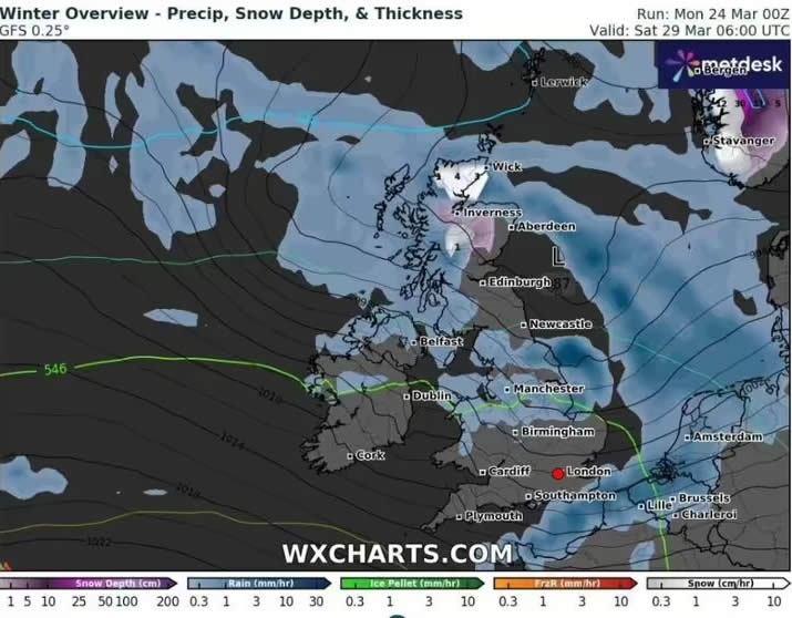
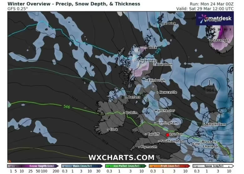
Things really start ramping up by midnight on Saturday, March 29, when large parts of the Highlands and surrounding areas could be properly blanketed in snow. Come 6 am, even the northernmost tip of the mainland – around places like Wick – could be waking up to a winter wonderland. And by Saturday evening, it looks like much of the affected areas in Scotland will be coated.
Although the snowfall could ease off by late weekend, a few patches of snow and rain may linger, especially in Scotland and Northern Ireland. The maps suggest by April 3, the wintry weather might finally back off, with only a few traces of snow clinging on in parts of the north.
The Met Office’s long-range forecast for March 28 to April 6 confirms things will stay unpredictable. They describe the end of March as “characterised by changeable weather patterns” – so expect a mix of showers, longer spells of rain (particularly up north), and a few sunny breaks here and there, especially in the south.
“Temperatures will mostly be near normal for the time of year,” they added, although early April could see more settled conditions taking over, with drier spells, light winds, and sunshine returning – at least for a while. Still, the odd rainy or windy day might pop up, and there’s a chance of chilly nights where skies stay clear and winds are calm.


As for today (Monday), the Met Office says most of England and Wales will start off cloudy with some fog on the hills, but things should brighten up nicely with warm sunshine in the afternoon. The northwest starts dry and sunny, but rain is expected to creep in later on.
Tonight looks dry for the south with some patchy frost overnight. Elsewhere, expect it to turn cloudier with rain pushing south as the night goes on.
And Tuesday? The south is looking a bit gloomier with cloud and patchy rain or drizzle, while the north gets the better deal – brighter skies and just the odd shower up in Scotland.
Brace yourselves, spring might be here on the calendar – but winter’s not done with us just yet.
Read Next:
- Rosalía shares health update after food poisoning incident during Milan concert
- Bad Bunny seeks $465,612 in legal fees after winning ‘Enséñame a Bailar’ lawsuit
- Britain’s oldest supermodel Daphne Selfe dies aged 97
- Jon Stewart jokes about chaos as ‘The Bachelorette’ season gets pulled after scandal
- Ariana Grande reveals the mental health breakthrough that helped her return to the stage