UK Braces for 750-Mile Rainstorm: Met Office Issues Weather Warnings
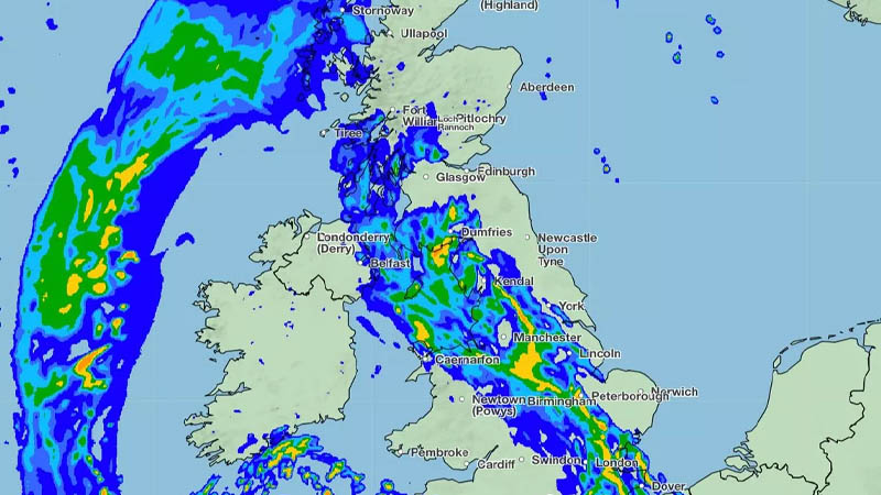
Share0This week, the UK is set to face a formidable 750-mile rainstorm, as the Met Office has issued warnings of substantial rainfall, predicting up to 6mm falling each hour in certain areas on Tuesday. The rainstorm, which has already prompted weather warnings for thunder today, is anticipated to impact a vast swath of the country, stretching from Dover in Kent to Tobermory in Scotland.
The Met Office’s alerts cover most of Northern Ireland, south Wales, and the southwestern counties of Devon and Cornwall. The deluge is expected to commence this afternoon (Monday) and persist into Tuesday morning, raising concerns about potential flooding due to the intense and continuous downpours.
The weather map for Tuesday morning vividly illustrates the extent of the rain, with the wall of water expected to drench many of Britain’s major cities, including Manchester, Birmingham, and London, as it sweeps from the southwest across the nation.
According to the Met Office, “Most northern and eastern areas will be fine with some warm sunshine. A few showers are expected across Scotland. Meanwhile, persistent rain feeding across Northern Ireland, Wales and southwest England. Rain across the north and east easing on Tuesday. Otherwise a mix of sunny spells and showers across the UK, the showers locally heavy and thundery. Warm in the sunshine.”
The forecast continues to outline a changeable pattern through the end of the week and over the weekend, with showers likely to develop each day across the UK. Southern regions may see the heaviest showers and the greatest risk of thunderstorms. Despite the unsettled weather, temperatures are expected to be around or slightly above average, feeling warm in sunnier spots.
The weekend may bring a brief respite as showers are predicted to ease from the north, leading to more settled conditions for a time. However, the forecast beyond the weekend remains uncertain, with mixed signals about the duration of higher pressure influences.
The Met Office concludes, “So after a potentially more settled spell of weather, unsettled conditions are likely to return during the week with the wettest conditions in the west. Above average temperatures are more likely than below.” This weather pattern follows a notably warm period where temperatures exceeded 24C across the UK on each of the past three days, reaching a high of 25.9C in Herstmonceux, East Sussex, on Saturday.
